Portfolio
Mississippi River Revetments
Since 2001, the New Orleans District Corps of Engineers Channel Stabilization has selected Chustz Surveying for their Automated Revetment Surveys Contract.

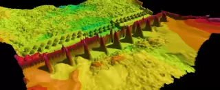
Since 2001, the New Orleans District Corps of Engineers Channel Stabilization has selected Chustz Surveying for their Automated Revetment Surveys Contract along the Mississippi, Atchafalaya, and Red Rivers from Mile 326.0 to Mile 0.0 utilizing multi-beam hydrographic and real-time mobile terrestrial laser line scanning survey methods.
The surveys are obtained using Differential Global Positioning Systems (DGPS) for horizontal positioning of the survey vessel. Vertical control is referenced to the Automated River Gages and the data is tide corrected per hour. CSI has developed a strategic work plan to cover as much geographic area as possible by deploying multiple survey vessels on all three waterways to efficiently collect the data.
A Riegl LMS-Q120 2D laser scanner, Reson Seabat 7101, R2Sonic 2024, an R2Sonic 2022, and Odom Shallow Water ES3 multibeam echo sounders are utilized to perform these surveys, each with its own specialized application.
Project Gallery