Portfolio
Impala Terminals
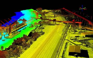
Chustz Surveying Inc. was requested to perform high-resolution multibeam and LiDAR surveys of the Impala Terminals Burnside facility in Darrow, Louisiana at Mississippi River mile 170.
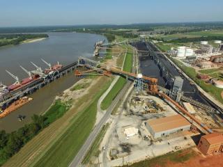
The topographic survey encompassed the entire facility and the hydrographic survey covered from water’s edge to approximately 1200 feet into the Mississippi River.
On September 15, 2016, Chustz deployed a two-person multibeam hydrographic survey crew with a 28-foot survey vessel equipped with a Reason Seabat 7101 Multibeam Surveying System to the site to collect the required hydrographic data. A four-person crew was deployed on September 21 to the site to establish control utilizing RTK and GPS surveying methods. A two-person Aerial LiDAR crew was also deployed the same day to begin the aerial survey with our RiEGL RiCOPPER. Horizontal control was tied to the state plane coordinate system while vertical control was referenced to NAVD88.
The Aerial LiDAR data was processed using RIEGL’s RiProcess software while the RTK and Conventional data were processed utilizing Trimble TBC software. The hydrographic data was processed using the latest version of HYPACK and the data sets were merged and underwent our QC/QA procedures. Final deliverables were then prepared and submitted on time.
Project Gallery