Portfolio
Louisiana DOTD Cable Barrier Project
Chustz Surveying was approached by the LaDOTD to execute a pilot project to collect survey-grade LiDAR data along one of Louisiana’s busiest highways.
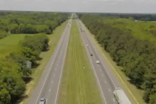
In 2017, Chustz Surveying was approached by the Louisiana Department of Transportation and Development (LaDOTD) to help develop and execute a pilot project to collect survey-grade LiDAR data along one of Louisiana’s busiest highways. The goal was to utilize new technology to increase safety for workers, cut costs to taxpayers, and decrease project time. Working with multiple Federal, State, and local officials, Chustz Surveying designed a methodology and obtained all the necessary approvals from governing agencies to perform the first LiDAR acquisition along a 40-mile corridor of Interstate-10.
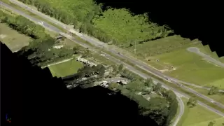
It was estimated that a three-person survey crew using traditional surveying methods would have taken 140 days to complete the project. In addition, they would have only collected cross-sections every 50 ft and would have only captured data in the median of the highway. Through the use of a LiDAR equipped small unmanned aircraft system (sUAS), Chustz Surveying was able to collect the data in 9 days, with an additional 18 days of processing QA/QC. This included a 1000 foot swath with an average of 37 points/ sq ft, resulting in significantly more detailed data than traditional survey methods would return. According to LaDOTD, the use of this technology saved LaDOTD just over $200,000 dollars. Based on a sample of 8,878 points, 82% of these points were 0.10 feet or less, and 95% were 0.15 feet or less (vertical).
Project Gallery