
Portfolio
No Name Bayou
CSI conducted a comprehensive survey of approximately 2.2 square miles at the No Name Bayou Marsh site for the Coastal Protection and Restoration Authority (CPRA).
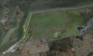
The survey consisted of 72 cross-sections at 250-foot intervals to cover the marsh fill site, roadway, and levees, three centerline profiles with additional cross-sections at 500-foot intervals, establishing two baselines, setting one staff gage, a full topographic survey of surface features and infrastructure, average marsh elevation shots in five sites, and a magnetometer survey to locate pipelines, obstructions or other anomalies.
A Static GPS Survey was conducted to establish horizontal and vertical control. The monument “No Name Bayou” was utilized on-site and the static GPS network was constrained to local CORS stations. Third Order Levels and RTK Survey methods were used to establish control throughout the site. A large portion of the area to be surveyed was marshland and our airboat was utilized to collect this data. The remaining marsh data was collected from our Gator Tail using RTK.
Project Gallery